
Major ocean currents and how they affect global temperatures

Hi everyone,

This week we're talking about ocean currents. Ocean currents are part of the ocean's circulation system and influence local and global weather patterns. They are produced by gravity, differences in water density, winds on the ocean surface and Earth's rotation on its own axis. They cause the movements and exchanges of different ocean properties such as salinity, temperature and nutrients. Ocean currents can flow at speeds of up to 4m per second however most flow at speeds between 5cm and 50cm per second. Weather patterns and ocean currents constantly influence one another. Ocean currents follow similar paths as global wind do, transferring heat from the equator to polar regions. They create and influence ecosystems worldwide, especially marine ones. However they also spread plastics and microplastics around the world far from their original source. This system of ocean currents is often referred to as a global conveyor belt. Today we're going to look at six major ocean currents.


Gulf Stream

The Gulf Stream is caused by movement of water in the Gulf of Mexico. It flows from the Caribbean up the eastern coast of the USA, before crossing the Atlantic and flowing towards the western coast of Europe. It is a warm surface current, meaning that it transports warm water to northeastern USA and into the Atlantic. As it reaches higher latitudes, it cools and the water sinks before flowing back towards the tropics. This current regulates the temperature in the North Atlantic region and causes milder winters in Western Europe. 
Gulf Stream

California Current

This current flows from the arctic, down the west coast of the USA and towards the equator. Arctic waters are known to be very rich in nutrients, so this cold, nutrient-rich current flows southwards and has a significant effect on local ecosystems. It is vital for many sea creatures especially marine mammals such as dolphins and whales.
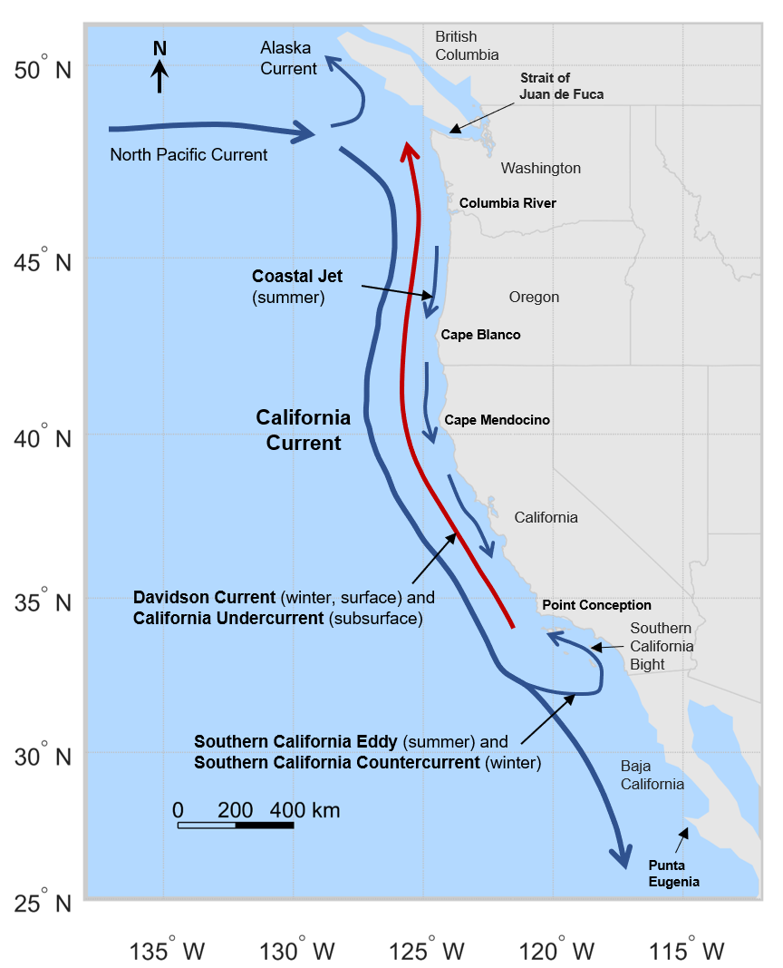
California Current

Kuroshio Current

The Kuroshio Current is caused by movements in western Pacific waters as the sun heats the ocean. This warm water flows up the east coast of Japan. It regulates the temperature in the North Pacific region and leads to milder winters in Japan and some other East Asian countries. It also serves as a migration route for many species.
Kuroshio Current


Agulhas Current

This current flows southwards down the East coast of Africa. It impacts the temperatures across the Indian Ocean Region and transports warmer water towards South Africa. This leads to higher temperatures in southeastern Africa. This current is also an important migration route.

Antarctic Circumpolar Current

The Antarctic Circumpolar Current is a cold surface current around Antarctica. It also transports cold water to the tropics. This current regulates the temperature of the Southern Ocean region and the coastal areas of Antarctica. 
Antarctic Circumpolar Current

Thermohaline Circulation

The Thermohaline Circulation is a global deep current. It's caused by differences in water density. Transporting warm water to the poles and cold water to the tropics, it affects surface temperatures worldwide and distributes heat and nutrients.
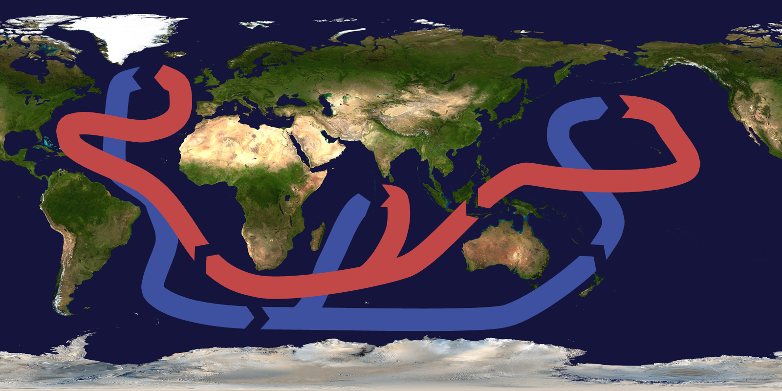
Thermohaline Circulation

We hope you enjoyed learning about different ocean currents and how they affect global temperatures. We'll be back next week!

Your Green World Blog Team💚


Sources:

Images:
Gulf Stream: Georges Clerc-Rampal, Public domain, via Wikimedia Commons
California Current: Cormorant24, CC BY-SA 4.0, via Wikimedia Commons
Kuroshio Current: Frank Geerlings, CC0, via Wikimedia Commons
Antarctic Circumpolar Current: NASA, Public domain, via Wikimedia Commons
Thermohaline Circulation: Brisbane, CC BY-SA 3.0, via Wikimedia Commons

Comments

Popular posts from this blog

How much do you know about trees? - Quiz

Hello, This month's quiz is all about trees. Questions: What is the name of the network that trees use to communicate? a) the mycorrhizal network b) the mythcorhinia network c) the symbocommunial network How much of the amazon rainforest has been lost due to deforestation in the last 50 years? a) 12% b) 17% c) 23% True or False? Over 75% of land-based species are found in forests? How much carbon do tropical forest contain? a) 230 gigatons b) 280 gigatons c) 330 gigatons In California, there is a rather strange tree that has survived 13 000 years by cloning itself. What species? a) Pin oak ;b) English oak c) Palmer's oak True or False? The oldest surviving tree species, Gingko trees, have been around since just after the meteor that killed off the dinosaurs struck. Where do acacia trees grow? a) cold and ha...

Ozone layer

Hi everyone, What even is ozone? And the ozone layer? Where does the hole in the ozone layer come from and what does it mean? Is it dangerous? What can be done? Often the ozone-talk can be complicated and confusing, keeping an overview is hard and understanding all the problems always difficult. Let us break it down a bit for you: What is the ozone layer? We'll start with the basics: The ozone layer is part of the stratosphere, which is the second layer of the Earth's atmosphere, between 10 and 50 km above the Earth's surface and made up of protective gases. One of these protective gases is ozone. There is not much ozone in the atmosphere, only 0.3 molecule of ozone per 1 million molecules of air. This is because ozone is chemically unstable and only forms when ultra violet radiation (UV light) hits oxygen and breaks the bonds between the atoms. It fact it is so unstable that even when it has formed, it breaks down again relatively quickly. This leads to ozone turning back ...

Eco system Galápagos: Part 1 Geography

Hello and welcome to the first post about the Galapagos Islands. Currents and Winds The volcanic islands of Galápagos started to form 4 million years ago. Where they lie, is unique. They are situated directly on the equator, on the Nazca tectonic plate. The Galapagos Islands are on the crossroads of three currents. The cold South Equatorial Current flows westward towards Galapagos. The warm Panama Current runs in from the north. And finally, the deep sea Cromwell Current runs from the west. The Galapagos Islands are also where the Northeast Trade Wind meets the Southeast Trade Wind. Galapagos Hotspot 21 Volcanoes make up the Galápagos Islands with 13 still active. The reason for this volcanic activity is a giant hotspot under the island. A hotspot is a gigantic column of super heated molten lava, rising up towards the surface. It is immense; at least sixty miles (97 kilometers) across and 1800 miles (2897 kilometers) deep. It connects the islands to ...

The life of ... an alcon blue butterfly

Hi everyone, Today we are going to be looking into the life of an alcon blue butterfly (Phengaris alcon). After mating, the females lay their eggs on marsh gentian, a blue-coloured wildflower. The eggs can only be laid on these flowers, as this is what the newly hatched caterpillars will eat. Although in some alp regions, they can also be found on willow gentians, a close relative of the marsh gentian. Once the caterpillars have hatched from the eggs, their main predator and danger are the ants that swarm below. But high on their plant homes, the caterpillars are safe. However, this isn't where the alcon blue caterpillars are going to stay forever. Eventually, they drop down to the ground using silk strings. With no protection, they are soon dragged off by the ants. The most amazing part is, the alcon blue caterpillars give off the same scent and chemicals as the ant larvae. So the ants take the caterpillars back to their brood chamber, wher...

The life of ... Atlantic salmon

Hello everyone, Today we're talking about Atlantic salmon. Atlantic salmon are found in the north Atlantic and the rivers that flow into it. They can grow up to a meter long and are classified as Least Concern by the IUCN . Atlantic salmon start their lives in rivers. The pea-sized eggs are laid in autumn and hatch in April or May. The tiny salmon are called alevins. They feed on aquatic invertabrates and eventually devolop into parr. Parr are easily recognised by destinictive patterns and markings on their flanks. After up to several years, the parr develop a silvery sheen. These replace those characteristic parr markings. Their bodies change in preparation for the salt water and they are now called smolts. They swim downstream with the current all the way to the ocean. In the deep sea waters, the smolts feed on crustaceans and small fish for 15-50 months. However they are hunted by a number of predators including, sharks, seals and of ...

June 2021 Factfile - some news from the past month, animals and our first plant of the month!

Hi Everyone! We’re terribly sorry for missing last month’s fact file (May). We have all had a busy few months. This is actually the May fact file coming out very late. The June fact file is cancelled. Because of this, this factfile contains news from both months. We are very sorry for the delay in this post. As announced in our last factfile, this post has a new feature to it; plant of the month. We hope you'll enjoy it! News: Sierra Leone has sold a rainforest for a Chinese Harbour Sierra Leone has sold 250 acres of beach and protected rainforest for £39m to build an industrial fishing harbour. It was home to many animals, including several endangered species. This will also have a disastrous impact on local communities, tourism and as I've already mentioned, the environment. Just click  here - It's an article about all the environmental disasters that happened in May. It shocked me. Red Squirrels were born ...

The Climate Book by Greta Thunberg | review & thoughts

Hi Everyone! You may be aware that Wednesday was International Women's Day, so today I wanted to share a book review for a book written by one of the most inspiring women of our generation: Greta Thunberg. She is, of course, the legendary creator of the Fridays For Future movement and has inspired thousands of children to skip school on Fridays to protest for the climate. She recently compiled a book, simply entitled: The Climate Book. Here are my thoughts. This is a compilation of articles and essays from the best climate scientists, activists and high-profile people, which makes up, in my opinion, the climate bible . It quite literally encompasses everything you may want to know about the climate crisis, from the science, to how it affects us, what we've done and have yet to do, and so much more. This book is everything. I have not yet read the whole thing, because let me tell you, this book is HUGE. It's also of course very den...

16.08.2020 Animal of the week: Elephant

Hello. On the 12th of August it was International Elephant Day, so we decided that this week's post should be about elephants. Elephants are the largest living land mammals. There are three types of elephant; the African bush elephant; the African forest elephant and the Asian elephant. African elephants have larger ears, whereas Asian elephants have smaller ears. Elephants use their trunks to breath, bring food and drink to their mouths and to grasp objects. Elephants' legs are like pillars. They carry the Elephant's massive weight. African bush elephants weigh 6000kg, Asian elephants weigh 4000kg and African forest elephants weigh 2700kg. Basically, they are very heavy.Elephants eat grasses, small plants, bushes, fruit, twigs, tree bark, and roots. Elephants can live up to 70 years old in the wild. They communicate by sight, touch and smell. Sadly, these wonderful mammals are in danger. African elephants are listed as vulne...

Eco System, Galapagos: part 3 Discovery and modern life

Hello Everyone, This post in our mini series is all about the discovery of the Galapagos. The islands are renowned for their evolution and extraordinary animals but how did we discover it and who? The first recorded visit to the Galapagos was completely by chance in 1535, when Fray Tomas De Berlanger found this undiscovered land during a voyage to Peru. There may have been others who saw the islands but he was the first to step foot on them. De Berlanga was Spanish and returned to the Spanish Empire, describing the islands and the animals that inhabited them. The group of islands was named "Insulae de los Galopegos" (Islands of the Tortoises) in an atlas published in 1570. The first full map of the islands was made in 1684 by Ambrose Cowley, who named the individual islands after some of his fellow pirates or after British royalty and high class citizens such as Lords. These names were used in the navigation charts of the islands that wer...

Linking climate change and inequality - 'The Great Carbon Divide'

Hey everyone, Have you heard of 'The great carbon divide‘? It is often referred to as the 'carbon footprint gap' or the 'emissions imbalance‘, and produces frightening numbers. The great carbon divide describes the huge gap between the amount of carbon dioxide the rich versus the poor emit, and these numbers shocked even us.  What does this mean?  There have been many different studies, and all of them show terrifying results. One study from the Guardian and Oxfam, reports that the richest 1% of the world's population emit more carbon than the poorest 66%. The richest 1% consist of 77 million people, which may seem like a lot at first, but the poorest 66% refers to over 5 billion people! Africa, which is home to 17% of the world's population, only causes 4% of the world's emissions. This top 1% emitted 16% of global CO2 emissions in 2019, that's 5.9 billion tonnes of CO2. Modelling suggests that it would take someone who isn't in the top 1% about 150...